Dorstfeld Schacht 3: Unterschied zwischen den Versionen
Zur Navigation springen
Zur Suche springen
K (Bot: Automatisierte Textersetzung (-Aktueller Zustand +)) |
Peter (Diskussion | Beiträge) K (Bilder hinzugefügt) |
||
| Zeile 1: | Zeile 1: | ||
{{Infobox Schacht | {{Infobox Schacht | ||
| FOTO = Dorstfeld_4_3.JPG | | FOTO = Dorstfeld_4_3.JPG | ||
| BILDBESCHREIBUNG1 = Dorstfeld Schacht 3 | | BILDBESCHREIBUNG1 = Protegohaube von Dorstfeld Schacht 3 in 2010 | ||
| NAME = Dorstfeld Schacht 3 | | NAME = Dorstfeld Schacht 3 | ||
| ALTERNATIVNAME = | | ALTERNATIVNAME = | ||
| Zeile 26: | Zeile 25: | ||
| LAGE_UNGENAU = | | LAGE_UNGENAU = | ||
}} | }} | ||
<gallery> | |||
Datei:Zeche Dorstfeld Schachtanlage 2-3 Kaue.jpg|Kaue von Dorstfeld Schachtanlage 2-3 in 2012. | |||
Datei:Zeche Dorstfeld Schachtanlage 2-3 Trafohaus.jpg|Trafohaus von Dorstfeld Schachtanlage 2-3 in 2012. | |||
</gallery> | |||
==Links== | ==Links== | ||
*[http://de.wikipedia.org/wiki/Zeche_Dorstfeld Wikipedia] | *[http://de.wikipedia.org/wiki/Zeche_Dorstfeld Wikipedia] | ||
*[http://www.zechensuche.de/dortmund.htm Zechensuche] | *[http://www.zechensuche.de/dortmund.htm Zechensuche] | ||
[[Kategorie:Zeche Dorstfeld]] | [[Kategorie:Zeche Dorstfeld]] | ||
Aktuelle Version vom 16. November 2012, 18:52 Uhr
| Schachtdaten: Dorstfeld Schacht 3 | |
|---|---|
 | |
| Bergwerk | Dorstfeld |
| Teufbeginn | 1902 |
| Betriebsende | 1963 |
| Sichtbar | Protegohaube |
| Geographische Lage | |
| Standort | Dortmund |
| Gemarkung | Dorstfeld |
| Strasse | Hügelstraße |
| Koordinaten | 51° 30′ 8″ N, 7° 25′ 6″ O51.502347.418231Koordinaten: 51° 30′ 8″ N, 7° 25′ 6″ O |
|
| |
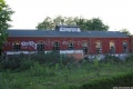
Kaue von Dorstfeld Schachtanlage 2-3 in 2012.
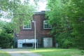
Trafohaus von Dorstfeld Schachtanlage 2-3 in 2012.

