Waltrop Schacht 1: Unterschied zwischen den Versionen
Zur Navigation springen
Zur Suche springen
K (Bot: Automatisierte Textersetzung (-Aktueller Zustand +)) |
Peter (Diskussion | Beiträge) K (Bilder hinzugefügt) |
||
| Zeile 1: | Zeile 1: | ||
{{Infobox Schacht | {{Infobox Schacht | ||
| FOTO = Zeche_Waltrop_Schacht_1_Bild_1.JPG | | FOTO = Zeche_Waltrop_Schacht_1_Bild_1.JPG | ||
| BILDBESCHREIBUNG1 = Waltrop Schacht 1 | | BILDBESCHREIBUNG1 = Position von Waltrop Schacht 1 in 2010 | ||
| NAME = Waltrop Schacht 1 | | NAME = Waltrop Schacht 1 | ||
| ALTERNATIVNAME = | | ALTERNATIVNAME = | ||
| Zeile 9: | Zeile 8: | ||
| TEUFE_JAHR = 1903 | | TEUFE_JAHR = 1903 | ||
| AUFGEGEBEN_JAHR = 1992 | | AUFGEGEBEN_JAHR = 1992 | ||
| GRÖSSTE_TIEFE = | | GRÖSSTE_TIEFE = 910 | ||
| DURCHMESSER = | | DURCHMESSER = | ||
| BAUART = | | BAUART = | ||
| Zeile 21: | Zeile 20: | ||
| STANDORT = Waltrop | | STANDORT = Waltrop | ||
| GEMARKUNG = | | GEMARKUNG = | ||
| STRASSE = | | STRASSE = Landabsatz | ||
| NOCH_VORHANDEN = | | NOCH_VORHANDEN = | ||
| LAGE_UNSICHER = | | LAGE_UNSICHER = | ||
| LAGE_UNGENAU = | | LAGE_UNGENAU = | ||
}} | }} | ||
<gallery> | |||
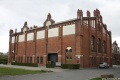
Datei:Zeche Waltrop Schacht 1 Maschinenhalle.JPG|Maschinenhalle von Waltrop Schacht 1 in 2013. | |||
</gallery> | |||
==Links== | ==Links== | ||
*[http://de.wikipedia.org/wiki/Zeche_Waltrop Wikipedia] | *[http://de.wikipedia.org/wiki/Zeche_Waltrop Wikipedia] | ||
*[http://www.zechensuche.de/waltrop.htm Zechensuche] | *[http://www.zechensuche.de/waltrop.htm Zechensuche] | ||
*[http://www.ruhrzechenaus.de/recklinghausen/re-waltrop.html Ruhrzechenaus] | |||
[[Kategorie:Zeche Waltrop]] | [[Kategorie:Zeche Waltrop]] | ||
Aktuelle Version vom 3. April 2013, 18:48 Uhr
| Schachtdaten: Waltrop Schacht 1 | |
|---|---|
 | |
| Bergwerk | Waltrop |
| Teufe (Größte Tiefe) | 910 m |
| Teufbeginn | 1903 |
| Betriebsende | 1992 |
| Sichtbar | Rohr |
| Geographische Lage | |
| Standort | Waltrop |
| Strasse | Landabsatz |
| Koordinaten | 51° 37′ 3″ N, 7° 25′ 11″ O51.6176117.419828Koordinaten: 51° 37′ 3″ N, 7° 25′ 11″ O |
|
| |
Maschinenhalle von Waltrop Schacht 1 in 2013.
